Ibelin Balian’s quick summary, hopefully useful to the community.
Which route do you care about, leave a comment, will write a separate article for each route in more detail (planning, progress, bidding situation, investment divergence).
—–
A. GOAL
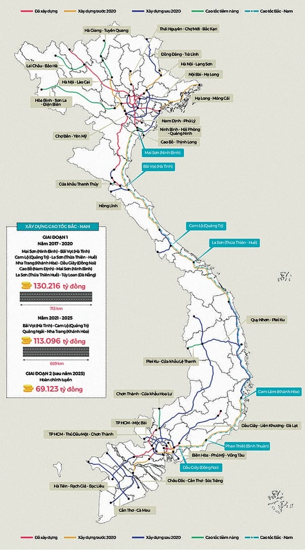
To form a national expressway network, ensuring the connection of key economic centers, major border gates, and important traffic hubs with high and high speed transport demands. In particular, the North-South expressway will be concentrated, with priority given to the route connecting Hanoi, Ho Chi Minh City, Da Nang, and routes to major ports.
Create high links with other modern transport modes and international integration.
Expressways are set up separately, but must be linked to the existing road network, and ensure the environment and landscape.
Contribute to solving traffic jams in Hanoi and Ho Chi Minh City.
Expressways in the Master Plan are planned with a complete scale, but during the implementation, construction can be phased in to match vehicle traffic and capital mobilization, but must manage land fund to limit spending. clearance fees.
B. PLAN FOR DEVELOPING A Nationwide High Speed Network
On the basis of the forecasting of transport demand, the socio-economic development orientation of the country; economic development orientation of 3 key economic regions; Transport development strategy to 2020 and vision after 2020, Vietnam expressway network establishment planning includes the following lines
B1. NORTH-SOUTH Expressway
Including 02 routes, a total of 3,262 km.
1. North-South Expressway in the East (CT1), 1,941 km.
Including 16 sections of the route with the following nodes: Hanoi, Ninh Binh, Thanh Hoa, Ha Tinh, Quang Tri, Da Nang, Quang Ngai, Binh Dinh, Nha Trang, Phan Thiet, Dau Giay, Long Thanh, Ben Luc, Trung Luong , My Thuan and Can Tho.
2. North – South West Expressway (CT2), 1,321 km.
The route goes through 23 provinces and cities: Tuyen Quang, Phu Tho, Hanoi, Hoa Binh, Thanh Hoa, Nghe An, Ha Tinh, Quang Binh, Quang Tri, Thua Thien Hue, Da Nang City, Quang Nam, Kon Tum , Gia Lai, Dak Lak, Dak Nong, Binh Phuoc, Binh Duong, Tay Ninh, Long An, Dong Thap, Can Tho, Kien Giang.
B2. NORTHERN REGION
07 radial routes connecting Hanoi, total 1,099 km.
1. Lang Son – Bac Giang – Bac Ninh, 130 km.
2. Hanoi – Hai Phong, 105 km.
3. Hanoi – Viet Tri – Lao Cai, 264 km.
4. Noi Bai – Ha Long – Mong Cai, 294 km.
5. Hanoi – Thai Nguyen – Cho Moi, 90 km.
6. Lang – Hoa Lac – Hoa Binh, 56 km.
7. Ninh Binh – Hai Phong – Quang Ninh, 160 km.
B3. CENTRAL – TAY NGUYEN
03 routes, total 264 km
1. Hong Linh – Huong Son, 34 km.
2. Cam Lo – Lao Bao, 70 km.
3. Quy Nhon – Pleiku, 160 km.
B4. THE SOUTHERN AREA
07 routes, total 984 km
1. Bien Hoa – Vung Tau, 76 km.
2. Dau Giay – Da Lat, 209 km.
3. HCMC – Thu Dau Mot – Chon Thanh, 69 km.
4. HCMC – Moc Bai, 55 km.
5. Chau Doc – Can Tho – Soc Trang, 200 km.
6. Ha Tien – Rach Gia – Bac Lieu, 225 km.
7. Can Tho – Ca Mau, 150 km.
B5. IN HANOI CITY
Belt 3, 56 km.
Belt 4, 125 km.
Ring Road 5, 331km.
B6. IN HO CHI MINH CITY
Belt 3, 83 km.
Belt 4, 197 km.
——-
Currently, the Ministry of Transport continues to study, submit additional plans to the plan of many new routes and adjust the Bien Hoa-Vung Tau route.
